Visualising the Conflict
GIS Maps, Google Maps, and Virtual Educational Space
GIS Mapping by Luke Kelleher;
Google Map Development by
Julio Lopez Losada;
Virtual Educational Space Development by Kerri McCusker and Julio Lopez Losada
|
This page provides links to the main outputs from the 'Visualising the Conflict' project which was funded by the AHRC. It was a follow-up to the earlier 'Victims, Survivors and Commemoration' project.
The major outputs are:
- a series of GIS Maps (Geographical Information Systems maps) of deaths related to the conflict and physical memorials in public spaces;
- interactive Google Maps displaying information on physical memorials and deaths as a result of the conflict;
- a virtual educational space, developed in Second Life and backed-up in OpenSim, which allows users to interact with information and 3D models of physical memorials;
- short videos of a selection of physical memorials; and
- a set of Project Guides and other outputs.
The links below contain further information and the resources. The information can also be found via the 'Map+' drop-down menu on the right-hand side of the above menu bar.
 Introduction Introduction
Introduction to the 'Visualising the Conflict' project, funded by the AHRC. |
GIS Maps
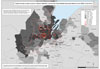 24 sets of GIS maps, in various formats, displaying information about deaths due to the conflict (1969-2001) and physical memorials to the conflict, that users can view or download. 24 sets of GIS maps, in various formats, displaying information about deaths due to the conflict (1969-2001) and physical memorials to the conflict, that users can view or download. |
Suplementary GIS Graphs
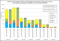 4 sets of GIS graphs, in various formats, that users can view or download. The graphs were produced using GIS software and are intended to supplement the information contained in the GIS Maps above. 4 sets of GIS graphs, in various formats, that users can view or download. The graphs were produced using GIS software and are intended to supplement the information contained in the GIS Maps above. |
Suplementary GIS Tables
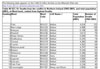 2 GIS tables, in various formats, that users can view or download. The tables were produced using GIS software and are intended to supplement the GIS maps above. 2 GIS tables, in various formats, that users can view or download. The tables were produced using GIS software and are intended to supplement the GIS maps above.
[NOTE: Additional tables to be added] |
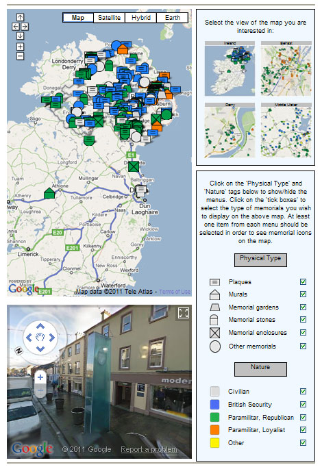
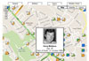
Google Map of Physical Memorials
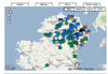 A Google Map of Ireland with an interactive overlay of the location of physical memorials to the conflict. The 'vew' button (to the right) opens the main / default Google map (and Google Street View). A Google Map of Ireland with an interactive overlay of the location of physical memorials to the conflict. The 'vew' button (to the right) opens the main / default Google map (and Google Street View).
Five different versions of this map are also available. |
D R A F T Google Map of Deaths
 A DRAFT Google Map with an interactive overlay of the location of deaths as a result of the conflict. Due to possible delays in downloading the pointer information for the large number of deaths in the database, this map has been set to open without any points displayed. Users have to select the information they wish to see displayed on the map. A DRAFT Google Map with an interactive overlay of the location of deaths as a result of the conflict. Due to possible delays in downloading the pointer information for the large number of deaths in the database, this map has been set to open without any points displayed. Users have to select the information they wish to see displayed on the map.
Important: Before using this Google Map for the first time, please read the NOTE. |
Virtual Educational Space
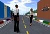 A guide and introduction to the layout, and content, of the information presented in a virtual educational space using the Second Life platform (with a backup on OpenSim). The guide also contains information on how to access the virtual educational space in Second Life. A guide and introduction to the layout, and content, of the information presented in a virtual educational space using the Second Life platform (with a backup on OpenSim). The guide also contains information on how to access the virtual educational space in Second Life. |
Video
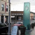 Video footage of a selection of physical memorials. This footage is included to complement the still photographs in the memorials database, the street view embedded with the Google map, and also the 3D models in the virtual educational space. The video will give users a better sense of the scale and the environment in which the memorials are situated.
 |
Other Project Outputs
A list, with links to documents, of other outputs produced as part of the project. The outputs include: Project Guides; Conference Paper; Conference Presentations; Other Presentations; Virtual Presentations; and Other Publicity Materials. |
|